Initial scoping
“Ko te whenua ko au. Ko au ko te whenua.” / I am the land, the land is me.
Tikanga and mātauranga Māori are the key foundations of this game, and as such, it needs to start with the two core pillars of Māori society. Ko te whenua ko au, I am the land. Ko au ko te whenua, the land is me. Even the Māori name for people is tangata whenua, people of the land. As such, before starting on any game mechanics, I need a database of those two things. Whakapapa/genealogy and rohe/location mapping will be the first steps.
Whakapapa/Genealogy
Whakapapa, your ancestry, is such a key part of the Māori worldview. In many cases it decided who would join you in war, who would have access to resources and how they were distributed. Who held power. It reached every facet of life. Mapping as much of the whakapapa of our key players as possible is core to building a reactive diplomatic system, and to filling out the rosters with as many real people as possible.
I've mined the Waitangi Tribunal settlement documents and evidence, namely the oral and traditional history reports plus the related evidence where a lot of whakapapa charts are stored, in addition to books and reports.
Rohe/Location
The land is also key. By researching maps and oral histories, we can place not just pā (hill forts) and kāinga (villages) but also numerous other locations, such as traditional hunting and fishing areas, market gardens, logging and kauri forestry areas, mission stations, natural harbours, trading ports, traditional pathways, roads and shipping routes. All of these let us develop a fully lived-in world map that can serve as an accurate sandbox to explore NZ history.
Sources
Every record in the whakapapa and location databases goes back to a source. Most of it comes from Waitangi Tribunal material, since the oral and traditional reports and evidence hold a lot of whakapapa charts and pā and kāinga locations. Tribal histories, settlement deeds, journal articles and archival records fill in around that. Below is a general list of where I've looked so far;
- Waitangi Tribunal district inquiry reports, such as Te Raki (Wai 1040), Hauraki, Te Urewera, Te Mana Whatu Ahuru, He Maunga Rongo, Wairarapa ki Tararua, Te Tau Ihu, Taranaki and the Ngāi Tahu report.
- Tribunal evidence, around 300 documents so far: oral and traditional history reports, hapū kōrero, claimant briefs, and the document banks holding Native Land Court minute book extracts.
- Treaty settlement deeds and their schedules, around 45 of them.
- Iwi-authored histories and reports, such as Ngā Hekenga o Te Ātiawa, Mōkai Pātea: Mana Whenua Mana Tangata and the Patuharakeke traditional report, plus iwi manuscripts published online.
- Tribal histories, such as Kelly's Tainui, Smith's History and Traditions of the Maoris of the West Coast, Stone's From Tāmaki-makau-rau to Auckland, Sadler's Ko Tautoro, Urlich Cloher's The Tribes of Muriwhenua, Monin's Hauraki Contested and Taylor's Lore and History of the South Island Maori.
- Journal articles, most from the Journal of the Polynesian Society, like Best's The Land of Tara and Gudgeon's Maori Tribes of the East Coast.
- Musket Wars histories, like Crosby's The Musket Wars and Ballara's Taua.
- The Dictionary of New Zealand Biography and Te Ara.
- Papers Past, for newspapers like Te Tiupiri.
- Land records: Turton's Maori Deeds of Old Private Land Purchases and the Old Land Claims case files at Archives New Zealand.
- Whakapapa charts and kōrero I've supplied myself.
- The LINZ gazetteer for place names and coordinates, and LINZ topographic data for coastline, rivers, lakes, swamp and sand.
- Landcare Research land cover and potential vegetation data.
- Historical maps, such as Kelly's 1949 Tainui map, the maps in Salmond's Between Worlds and the sketch maps in the Old Land Claims.
- The same Tribunal reports and tribal histories, for pā, kāinga and who held them in 1810.
Whakapapa Editor
Once the whakapapa started coming in I needed a way to see it. A spreadsheet of thousands of people can't show you whether a line holds together, or whether the same tūpuna has come in twice from two different sources.
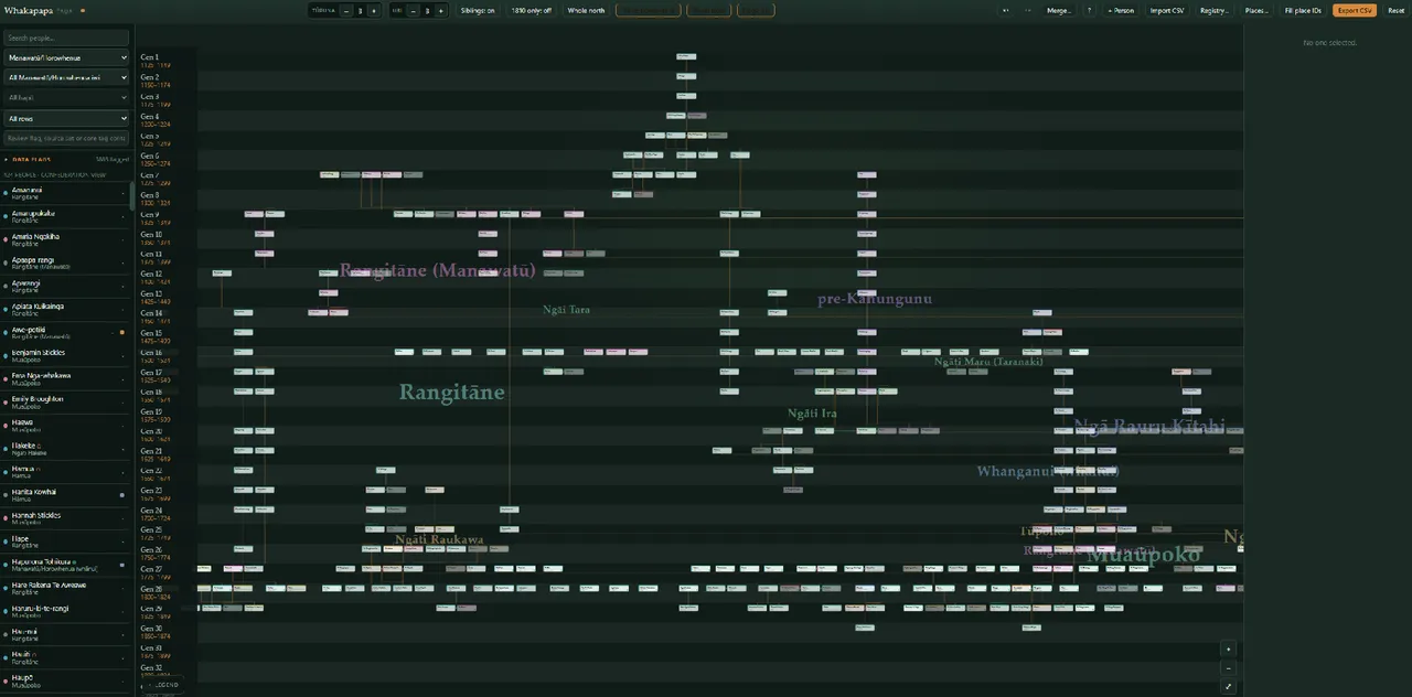
For ease of use I built a whakapapa editor for this, with help from AI coding tools. It reads and writes to a excel datasheet, but still requires manual entry and vetting of the data itself. It is solely a tool to view the data and edit it more easily.
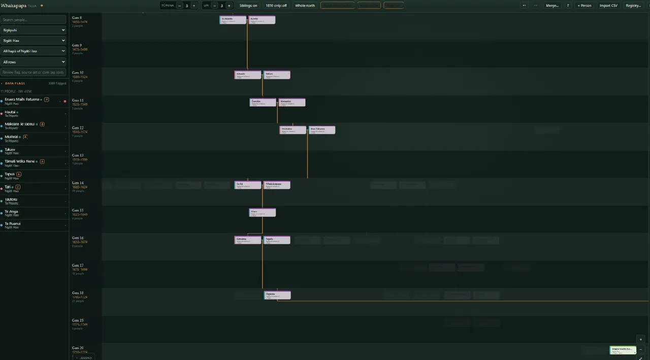
You can filter by iwi or hapū, select a person and light up their tūpuna and uri. Here it's Eruera Maihi Patuone of Ngāti Hao, traced back through Maikuku and Uenuku to Rāhiri and Āhuaiti. That link back to the hapū and iwi ancestors is key for the game, since kinship decides who turns up when a hapū calls for support in war.
Stored Data
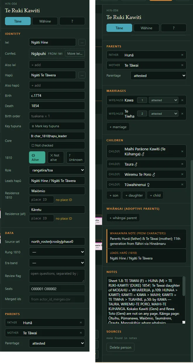
Each data entry contains a person's iwi, hapū, dates, parents, marriages, children, where they lived in 1810 and the source notes. Te Ruki Kawiti's data as above has him as Ngāti Hine, leading Ngāti Te Tāwera, born c.1774 and died 1854, living at Waiōmio in 1810 with Kāretu as a second residence. I've marked his parents Hunā and Te Tāwai as attested, and the notes keep each source's wording and page, including the line placing him eleven generations from Rāhiri through Hineāmaru.
Rules
A few rules I stick to with the data. Wrong is worse than blank, so if no source gives a date or a parent, the field stays empty. Estimated dates get a "c." and every record gets a confidence grade from A to D. Where sources disagree, iwi-authored sources win and I keep the other version in the notes. I link rangatira with no recorded parents to their hapū line through a labelled placeholder, which comes out as soon as a source turns up.
The editor flags anything that looks off, like possible duplicates, date clashes or a parent younger than their child. There are 3,888 flags in the queue right now, and I'm working through them region by region.
Location Editor
The location editor is where the rohe side comes together. It holds 1,193 places across the North Island and the top of the South Island, including pā, kāinga, anchorages and resource sites, each with a record of who held it.
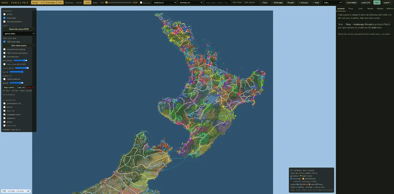
Each place has one controlling hapū per year, plus any other groups living there, paying tribute or using it for part of the year. Moving the year slider redraws the territories from whoever controls each place in that year, so the territories come from the places people held.
Confederations work the same way. A confederation was a kin grouping and never held its own rohe, so its ground on the map is the ground of its hapū.
Bay of Islands
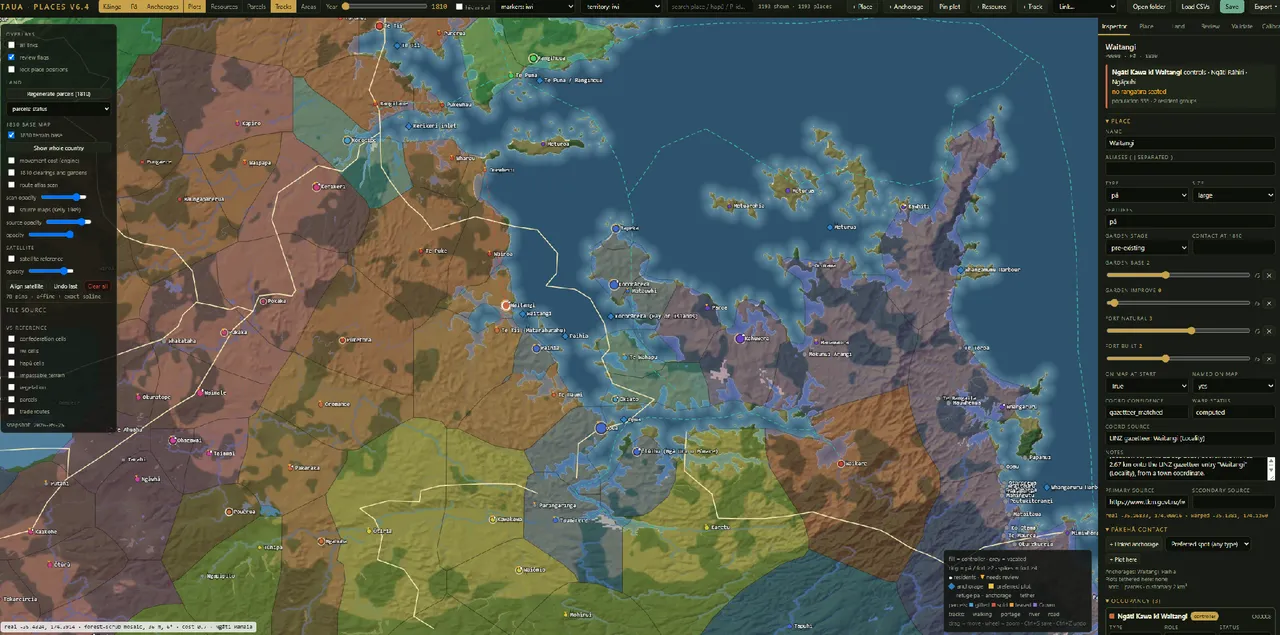
In the above view I've zoomed in on Te Pēwhairangi and selected Waitangi. Ngāti Kawa ki Waitangi of Ngāti Rāhiri hold it in 1810, a large pā with a population of 335. The inspector holds garden and fortification scores, linked anchorages at Waitangi and Paihia, and the source for the coordinate, in this case the LINZ gazetteer.
I built the base map from LINZ coastline, river, lake, swamp and sand data, with Landcare Research's potential vegetation layer for forest cover. I split tracks into walking routes, portages, rivers and roads, and these feed into movement in the game.
Place Data
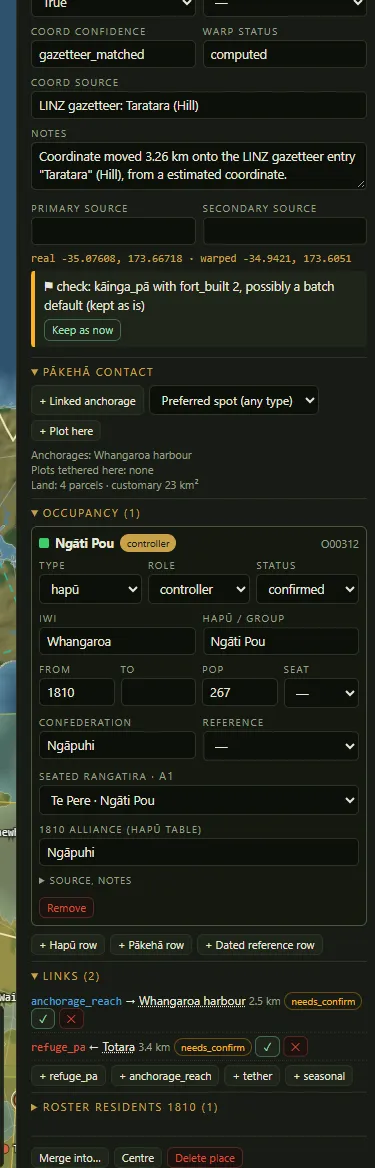
Taratara in Whangaroa is a good example of a full record. Ngāti Pou hold it in 1810 with an estimated 267 people and Te Pere as rangatira. It links to Tōtara as a refuge pā 3.4 km away and to Whangaroa Harbour as its anchorage. I've marked both links as needing confirmation until I check them against a source. The editor also flagged Taratara as a kāinga with a fortification score, which looks like a leftover from an early batch default, and left it for me to review.
Resource areas
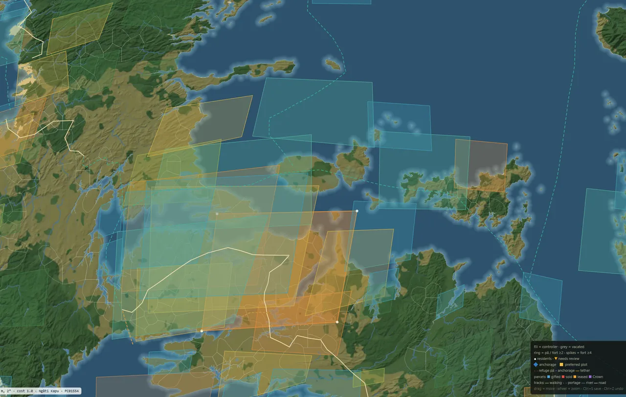
The map also holds 1,007 resource areas, covering timber, flax, fisheries, eel weirs, birding grounds, shellfish beds, gardens, hot springs and pounamu. I built around 95 of these by hand from sources for the north. I derived the rest from the terrain and LINZ data, such as flax from swamp, cropland from flat open ground near rivers, and harbours from how enclosed a stretch of water is. Each one takes the nearest Māori place name from the gazetteer, so no colonial names end up on an 1810 map.
To work out who holds each area, the editor checks the 1810 territory under its box. The hapū holding the most ground becomes the main holder, and the neighbouring hapū shares any area that straddles a boundary. Areas a long way from any settlement, like the inland Ruahine, Kaweka and Tararua ranges, stay blank.
In the game, resource areas feed into the value of the land around them and into what draws Pākehā in. Kauri, sheltered harbours and coastline count for the most, since sea access and kauri spars decided where Pākehā settled before 1840.
Pākehā arrivals
I haven't placed any missions, trading stations or shipyards on the 1810 map. They come in during play as plots tied to a host hapū, once a rangatira agrees to give or sell land. The historical dates, like Rangihoua in 1814 and Kerikeri in 1819, act as a guide. If the hapū you're playing never grants land, the mission looks for a neighbour who will.
The 1810 baseline stays fixed. I don't place anyone where they moved to after 1810, since migration and conquest happen in play.
Land Docs Comparison Evaluator
I am currently working through the old Land Claims are the case files from the Land Claims Commission, which the Crown set up after 1840 to rule on land Pākehā had bought from rangatira before the Treaty. Archives New Zealand holds many materials, including deeds, sworn evidence, sketch maps and the marks rangatira drew on the documents. For a game built on who lived where and who could give land away, they're a key source.
Transcription
An AI model downloaded around 4,500 pages of case files and did a first draft OCR transcription of the deeds, evidence and plans, with a little over 1,000 pages dating from before 1840. That gave me 8,846 mentions of Māori people, each with their role, how they were described, any hapū or place stated, and the excerpt it came from.
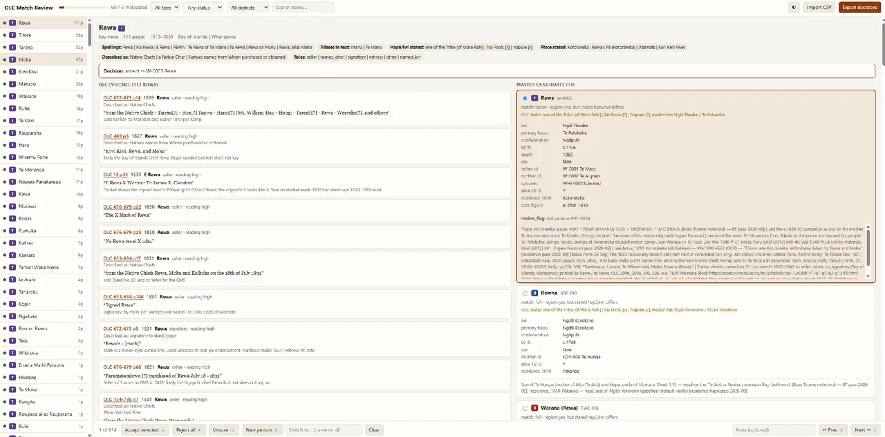
The evaluator groups every name by spelling and lines up the deed mentions on the left against possible matches from the whakapapa roster on the right. For each name I accept a match, reject them all, or add a new person.
Rewa is a good example. He shows up across 111 pages from 1819 to 1859 as a seller, witness and named chief, spelled Rewa, E Rewa or Te Rewa, and sometimes called Manu or Te Manu. The roster already has him as Rewa of Ngāi Tāwake and Te Patukeha, son of Te Maoi and Te Auparo, at Kororāreka in 1810. It also suggests a Rewha of Ngāti Korokoro born decades earlier, which is the kind of namesake I have to rule out by hand.
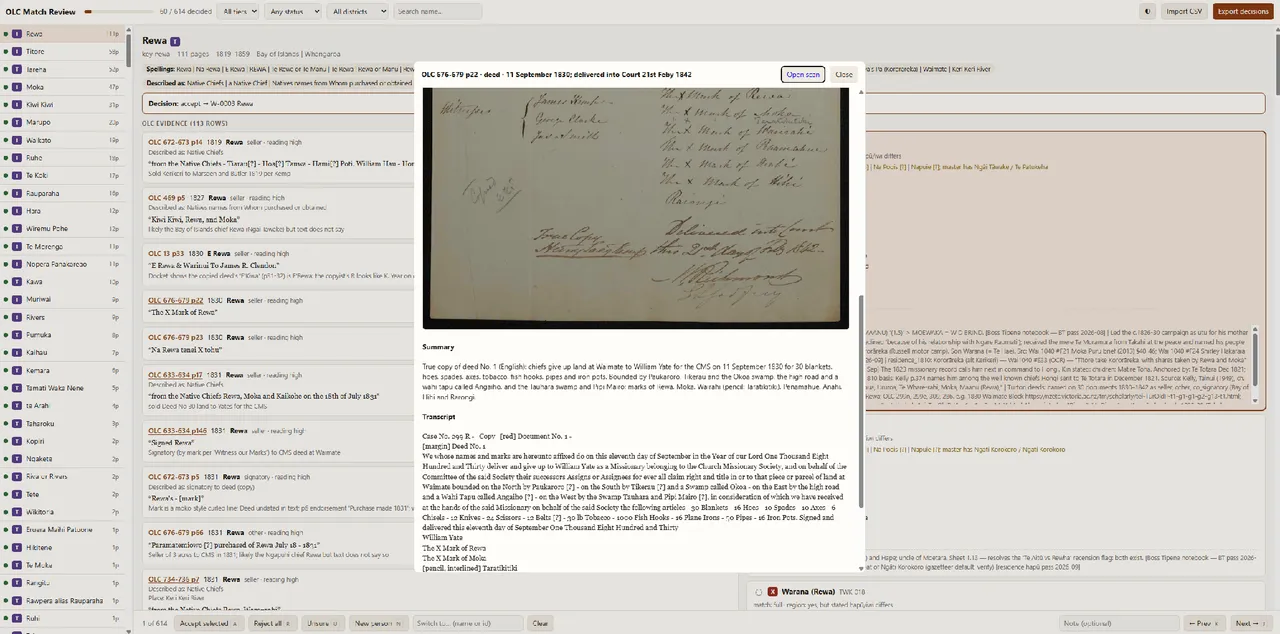
Clicking any reference opens the scan next to its transcript. This one is a copy of the 11 September 1830 deed where Rewa, Moka and other rangatira gave land at Waimate to William Yate for the Church Missionary Society, in exchange for 30 blankets, 16 hoes, 10 spades, 10 axes, 1,000 fish hooks, 30 lb of tobacco and other goods. The boundaries include the Okoa and Tauhara swamps and a wāhi tapu called Angaiho.
Most of these deeds are certified copies made in the 1840s, so most marks are a clerk's copy of the tohu. Some clerks wrote K and R almost the same, which turns E'Rewa into E'Kiwa on one docket. There are also several Hongi in the files who aren't Hongi Hika, and a place named next to a seller doesn't mean he lived there, so I only take residence from lines like "chief of" or "resident at".
I've already found corrections in the files. Kiwikiwi of Kororāreka has a death date of 1861 in the roster, but the claims describe him as dead by the late 1830s, with his widow giving evidence in 1841. Either the date is wrong or I've merged two people into one.
So far I've gone through 60 of 614 names.
Comments